

Main Content
Calgary Districts: Map & Community Guide
When people think of Calgary real estate, they think of quadrants: the Northwest, Northeast, Southwest and Southeast. If this is you, you’re right, of course. But when people search for Calgary districts, the current map looks very different: since 2016, the Calgary Real Estate Board (CREB®) has subdivided the city into eight districts instead of the traditional four-quadrant system.
For residents, homebuyers, sellers, real estate professionals, and anyone trying to understand how Calgary is organized, knowing these district boundaries makes it easier to compare neighbourhoods, property values, amenities, and the best fit for your lifestyle. Today, these include:
Calgary Districts
| City Centre | North |
| Northwest | Northeast |
| West | South |
| Southeast | East |
Below, we break down how the city’s zoning changed in 2016, what defines each of the eight districts, how those areas affect real estate decisions, and the common questions people have about Calgary’s districts.
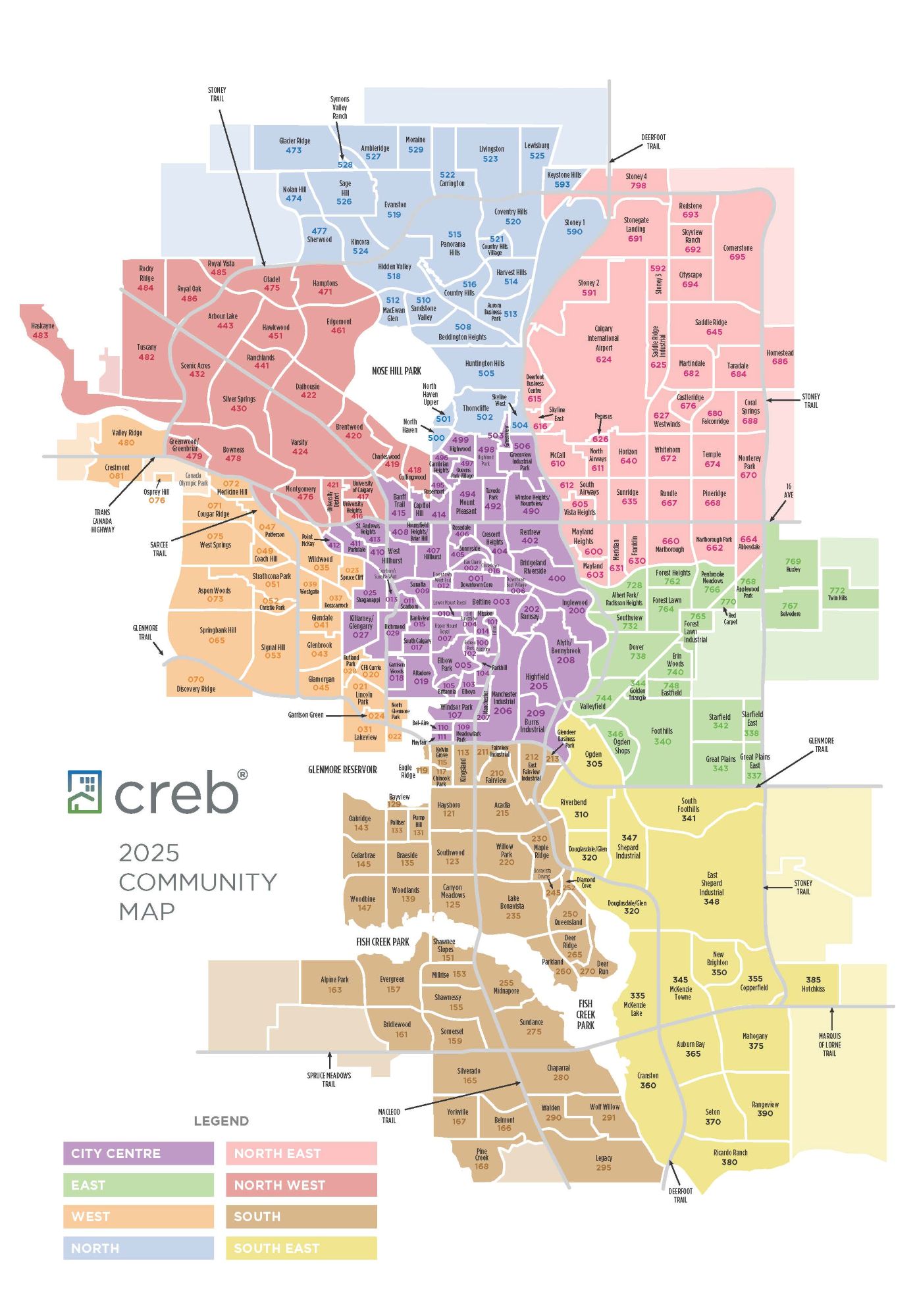
Map of Calgary Districts
Is There a Southwest District in Calgary?
Some people get confused by the fact that there is no “southwest” district in Calgary. Yes, there is a SW quadrant, but looking at the map above, how the city has subdivided its districts makes sense.
Despite having no “southwest” district, homes south of the Trans Canada Highway and West of Macleod Trail retain the SW quadrant designation in their address.
How CREB® Calgary Districts Affect You
CREB®’s implementation of the eight Calgary districts in 2016 brought changes that affected real estate agents and consumers in certain ways. However, these changes had marginal effects on how people buy and sell real estate in the Calgary Metropolitan Area (CMA).
What changed when the City of Calgary’s Districts were implemented?
- Eight Districts: The NW, NE, SW, and SE quadrants were divided into eight districts: the North, Northeast, Northwest, West, South, Southeast, East, and City Centre, with this MLS® re-alignment taking effect in January 2016. Clearer district alignment improved access to market and community data, enabling better decisions for buyers and sellers.
- Consolidation: Subdivisions within communities that had names ending in ‘estate’ were consolidated into their respective areas. For example, Arbour Lake Estates listings are now part of Arbour Lake MLS® search results.
- Name Changes: Names for all communities now match those specified by the City of Calgary for congruency. For example, Saddleridge was changed to ‘Saddle Ridge.’
Property Comparisons & Name Changes
CREB’s division of the four city quadrants into eight districts allows Realtors® and homebuyers/sellers alike to compare MLS® listings more easily. The updated district model also created clearer boundaries that better align community naming with how areas are compared today.
The North District in Calgary, for example, used to be split between the Northwest and Northeast quadrants. It is home to neighbourhoods such as Evanston, Harvest Hills and Coventry Hills (NW addresses) that have much different real estate portfolios than properties found in Martindale, Skyview Ranch, Redstone or Coral Springs (NE addresses).
While most communities have retained their names and previous quadrant/district, others saw a complete change. Panorama Hills, for example, used to be part of the Northwest quadrant; today, it is part of the North District. Meanwhile, Tuscany remains in the Northwest Calgary District, as always.
These are just a few examples of how CREB’s change in 2016 affected homeowners. Today, these changes are a thing of the past and likely long forgotten, although not everyone yet knows about each of Calgary’s districts, which we explore below.
City Centre District (CC)
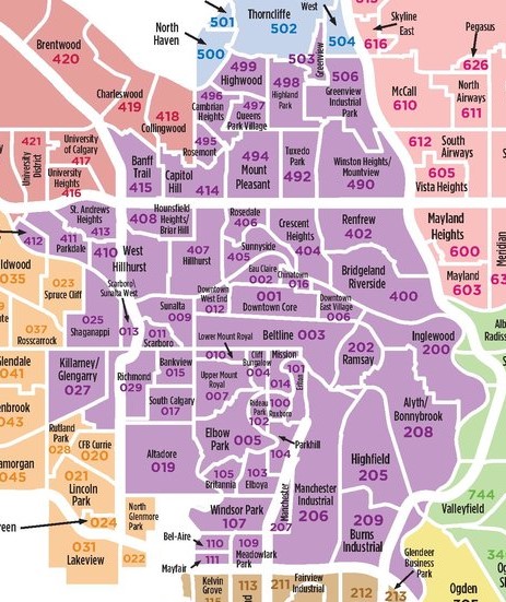
Calgary’s City Centre District includes all downtown and inner city communities. That includes neighbourhoods as far southwest as Killarney, as far southeast as Inglewood, as far south as Glenmore Trail and as far north as Highland Park.
The City Centre is perhaps one of the most desirable areas to live in Calgary for its close-to-everything location, with convenient access to the river, Eau Claire, East Village and other vibrant areas of the city.
Most of Calgary’s premier condominium buildings are located in the city centre area, including the downtown business core, East Village, Kensington, and the Beltline.
In general, the City Centre district is characterized by vibrant, eclectic streetscapes where people can access all the amenities they could hope for, often just a few blocks away on foot.
North Calgary District (N)
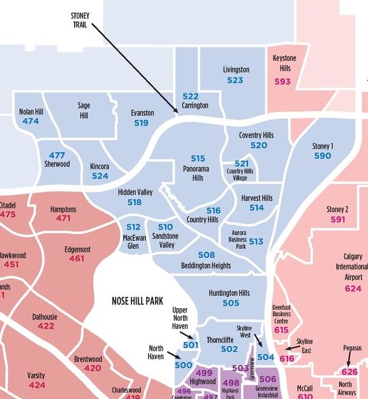
Calgary’s North District includes all communities on the east and north sides of Nose Hill Park that are also west of Deerfoot Trail. Evanston, Panorama and Nolan Hill, for example, are three award-winning neighbourhoods in the area.
The North District is known for its diverse terrain, which includes everything from plateaus to valleys amid the beautiful rolling foothills of Southern Alberta. Its neighbourhoods are well interconnected via beautiful ravines and paved pathways, making them family-oriented by design.
North residents benefit from quick access to major shopping areas like Beacon Hill and Creekside. Balzac’s Cross Iron Mills and North Horizon Mall are also easily accessed via Stoney Trail.
Escaping to the foothills and mountains is also easy when living in the North District of Calgary via the Stoney Trail ring road, as there is less traffic in the way.
Northwest Calgary District (NW)
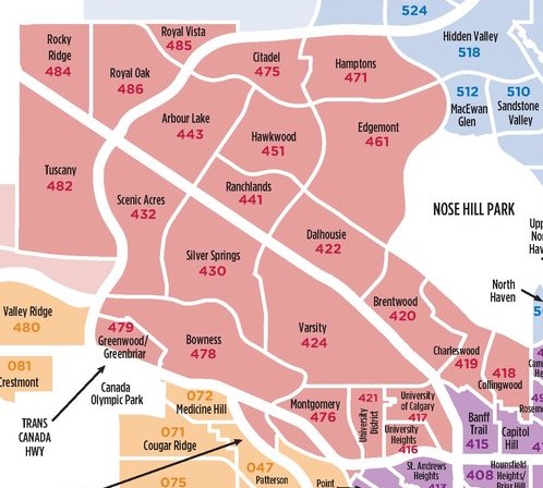
The Northwest Calgary District is to the west of Nose Hill Park and north of the Trans Canada Highway. It is home to popular family-oriented communities such as Tuscany, Bowness and Arbour Lake, and is an excellent area for Calgarians to live who frequent the foothills and mountains.
Calgary’s northwest is serviced by a C-Train line that runs along Crowchild Trail all the way to Tuscany, and even as far as Rocky Ridge. It is home to many green spaces and parks from the Bow River to the plateaus of Edgemont Estates.
Northwest residents have some of the best access to the foothills and mountains. Cochrane and other rural destinations out west such as Kananaskis Country, Banff and Jasper National Parks are conveniently accessed via Stoney and Crowchild Trails as well as the Trans Canada Highway.
The northwest is also home to major amenities including CF Market Mall, Royal Oak Centre, Crowfoot Crossing, Northland Mall, Brentwood, and many other strip malls that make life convenient.
Northeast Calgary District (NE)
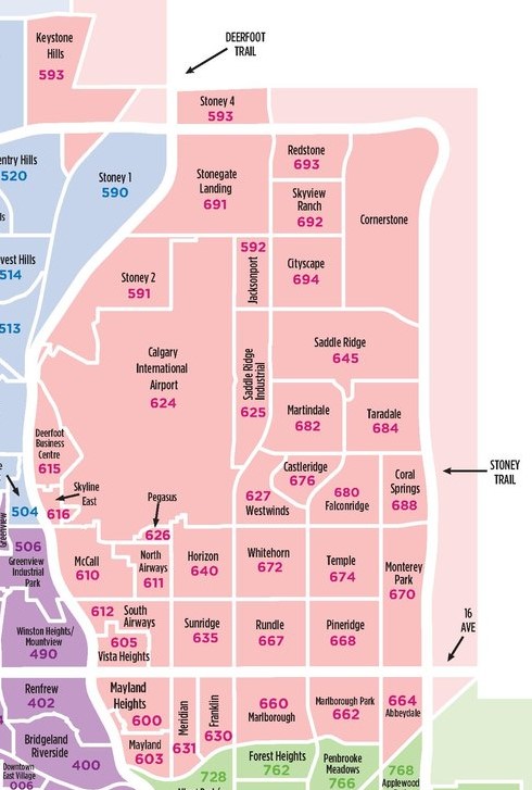
The northeast is a popular district in Calgary for those looking for more affordable living compared with most other areas of the city. However, some exceptions exist, such as Coral Springs, a lake community home to semi-estate properties and an exclusive homeowners’ association that hosts year-round activities and events.
YYC International Airport is located in the northeast part of the city, making this Calgary District an ideal place to live for frequent travellers. The Northeast is served by a C-Train line, an ideal arrangement for homeowners who rely on public transportation.
Northeast residents benefit from having some of the best access to a full spectrum of cultural restaurants, shops and services. Calgary’s Northeast is especially popular with established families and is also valued for good access to the Rocky Mountains. Several new construction communities like Cornerstone offer opportunities for homeowners looking to live in a newly built home.
West Calgary District (W)
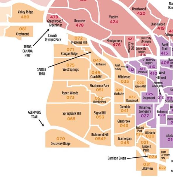
The West District in Calgary is perhaps the most sought-after in the city. Known for its high-end real estate portfolio in reputed communities such as Wentworth, West Springs and Aspen Woods, it is ideally located for families looking to live a suburban lifestyle not too far away from the City Centre – about a 15-minute drive.
Like the Northwest, Northeast, and South, Calgary’s West District is also serviced by a C-Train line that extends to 69th Street SW. The area is home to many private schools, including Rundle College, Calgary Academy, Webber Academy, and the Calgary French & International School.
Outdoor enthusiasts love the west for its close proximity to the mountains. This allows residents to skip the city traffic and escape to the Rockies much more efficiently than if they were living downtown or in the northeast, for example.
South Calgary District (S)
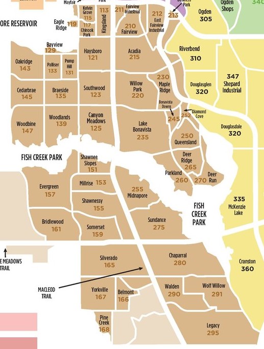
The South District in Calgary is perhaps better known by many Calgarians as the “Southwest.” Today, the South includes communities on both the east and west sides of Macleod Trail, featuring homes with both Southwest and Southeast Addresses.
This area is sought after by many for its tight-knit, family-oriented communities that provide residents with easy access to destinations such as Bragg Creek and Kananaskis Country. The South is also home to the massive Fish Creek Provincial Park, which spans from west to east, and exclusive lake communities such as Midnapore and Bonavista with active homeowner associations – neighbourhoods where families tend to stay for the long term.
Calgary’s South District is serviced by the South LRT line, making it convenient for teenagers and young adults who rely on public transportation to get from point A to point B. For all the reasons above, Calgary’s South is a top choice for many families.
Southeast Calgary District (SE)
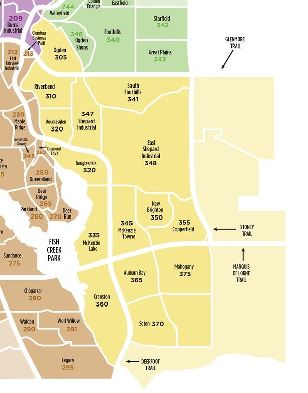
The Southeast District in Calgary is another family-oriented part of the city home to award-winning lake communities like Auburn Bay, McKenzie Lake and Mahogany. These neighbourhoods have a diverse real estate portfolio, ensuring home ownership and rental opportunities for people from many walks of life.
Calgary’s southeast is well connected to other parts of the city via Stoney and Deerfoot Trails. It offers quick and easy access to amenities in the Seton, Shawnessy and 130th Avenue complexes, new amenities at Belvedere via Stoney, and so much more!
The South Campus Hospital, our city’s newest healthcare facility, ensures residents have ample access to essential healthcare services. Set amid Seton, it is part of the Gateway Retail District, home to more than 130,000 square feet of retail space and various in-demand amenities such as restaurants, shops and services, including home department stores and movie theatres.
East Calgary District (E)
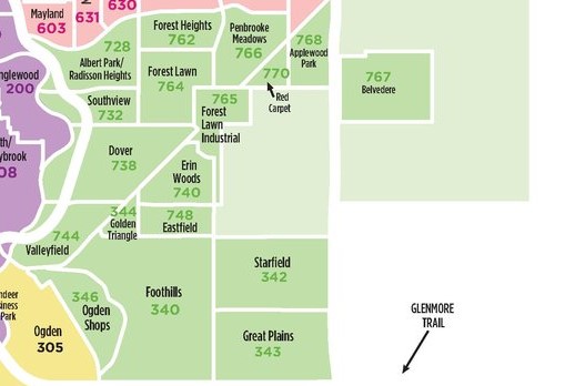
Calgary’s East District is known for its affordable real estate, while the Southeast District is one of Calgary’s fastest-growing areas with many master-planned communities featuring artificial lakes and beaches – perhaps the most affordable in the city compared to similar properties in other districts. Home to 17th Avenue SE, also known as ‘International Avenue,’ it is one of Calgary’s most ethnically diverse parts, with many cultural centres and temples dedicated to various faiths.
The East District in Calgary is home to an up-and-coming mixed-use community called Belvedere. Here, you’ll find Costco, Best Buy, Home Depot, and many more stores that make living nearby as convenient as possible. The Belvedere Infrastructure Plan is also host to a handful of emerging subdivisions, including Huxley, East Hills Crossing, and Liberty.
With access to the Stoney Trail ring road, East District residents can conveniently access other parts of the city. It is also not too far of a drive if heading west for leisure and recreation in the foothills and mountains is on the agenda.
Calgary Districts: Frequently Asked Questions

City Centre
What is the best district to live in Calgary?
Calgary’s districts each have their own unique features that would make any one of them the best to live in based on your wants, needs, and lifestyle.
For example, wealthy homeowners who value access to private schools may love the West District, while others who work for an airline and enjoy convenient access to the mountains may prefer living close to the YYC airport in the North or Northeast District.
The City Centre District is ideal for downtown workers who enjoy an urban lifestyle close to the office, as well as for young adults who want to live, work, and play in the heart of the city.
The South and Southeast Districts are home to many family-oriented suburban communities with central lakes and active homeowner associations, making them great places for children to grow up and create lasting memories with family/friends.
What are the residential districts in Calgary?
Calgary’s primary residential quadrants (not to be confused with its eight districts) include the Northwest, Northeast, Southwest, and Southeast. Across Calgary communities, each district offers a distinct lifestyle, from urban living to suburban family settings. Most of Calgary’s downtown and inner-city neighbourhoods are located in the SW and NW quadrants.
What divides “north” and “south” Calgary?
The Bow River divides Calgary’s north and south regions in the City Centre District. To its north are inner city communities like Sunnyside and Crescent Heights, while to the south you’ll find Eau Claire and the downtown business core.
Memorial Drive separates north and south Calgary to the east of downtown, while to the west, everything south of the plateau meandering along the Bow River is all considered part of the SW quadrant.
What divides “east” and “west” Calgary?
North of 9th Avenue SW in downtown Calgary, Centre Street divides the east and west parts of the city. South of 9th Avenue SW, however, Macleod Trail divides the east and west.
What is the oldest district in Calgary?
Inglewood is Calgary’s oldest neighbourhood, located directly across from Fort Calgary at the confluence of the two rivers (Bow and Elbow). Other old communities nearby include East Village, downtown, and the Beltline.
However, the City Centre wins by far in terms of being the oldest district. It is home to many historical buildings dating from the late 1800s and early 1900s – about as old as it gets for the City of Calgary.
Questions About Districts in Calgary?

As highly experienced Realtors® in Calgary, we would love the opportunity to answer any questions you may have about Calgary districts. Don’t hesitate to contact us anytime to discuss your real estate goals — we are looking forward to connecting with you!
Required fields are marked*
- Airdrie
- Alberta
- Arts and Culture
- Blog
- Buying Tips
- Calgary
- Calgary Activities and Events
- Calgary Communities
- Calgary Condo Guide
- Calgary Infill Homes
- Calgary Luxury Homes
- Calgary New Condo Guide
- Calgary New Homes
- Calgary Real Estate Statistics
- Calgary Restaurants
- Calgary Townhomes
- Canada
- Chestermere
- Condo Building Review
- Condos in Calgary
- Featured Blog Posts
- Featured Blogs
- First Time Home Buyers Guide
- Listings
- Moving to Calgary
- New Condo Projects
- Oil and Gas
- Okotoks
- Selling Tips
- Slider
- Testimonials
- The Best in Calgary
- Uncategorized
- Video Testimonials
- Contact Us
- Search MLS®
- Sellers’ Guide
- Buyers’ Guide
- About Cody & Jordan
- Blog
- Testimonials
- Downtown Calgary
- SW Calgary
- SE Calgary
- NE Calgary
- NW Calgary
- Calgary Condos
- Calgary Townhomes
- Calgary Infills
- Calgary Luxury Homes
- New Calgary Homes
- New Calgary Condos
- Acreages for Sale
- Bungalows for Sale
- Duplexes for Sale